
Background
About My Trail Hiking Application
MyTrails is a highly specialized mobile application tailored for advanced hikers and off-trail foragers, providing them with a robust set of tools to navigate and track their wilderness journeys. Recognizing the diverse needs of these users, MyTrails was designed to offer a personalized and adaptive interface, allowing users to customize the application according to their specific requirements. This flexibility enables hikers and foragers to layer various features such as topography, weather, distance tracking, and environmental details (e.g., grasslands, forests, beaches, deserts) directly onto the interface. The ability to add or remove these elements ensures that users have access to the precise information they need, enhancing both safety and efficiency in the wilderness.
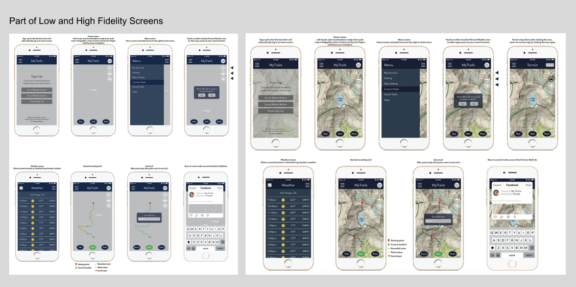
The development process began with a conceptual stage, where user research and field studies were conducted to understand the needs and challenges faced by the target audience. Low-fidelity wireframes and mockups were then created to visualize the core user flows and interactions. These initial designs focused on simplicity and ease of use, keeping in mind the demanding environments where the app would be used, often in remote areas with limited connectivity.
As the project progressed, high-fidelity mockups were developed to incorporate brand identity and refined user interface elements. These designs placed a strong emphasis on clear visual hierarchy, intuitive touch interactions, and the seamless integration of various data layers. The application’s interface was crafted with careful attention to the needs of its users, ensuring that all critical features were easily accessible, even in challenging conditions.
To bring the designs to life, prototypes were built to simulate real-world usage, allowing for iterative testing and refinement. Usability testing in the field, where the app was used in different outdoor settings, provided valuable feedback. This ensured that the final design was both user-friendly and adaptable to the dynamic nature of hiking and foraging activities. Key considerations, such as offline functionality, data accuracy, and legibility in varying lighting conditions, were integrated into the final product.
MyTrails ultimately emerged as a powerful, customizable tool for wilderness navigation. By offering an intuitive user experience with flexible features tailored to personal preferences, MyTrails enhances the outdoor adventure experience, helping users track their journeys, stay informed about environmental conditions, and navigate with confidence in any terrain.
Project Summary
While there are many hiking apps available, most fall short of meeting the needs of more experienced and extreme hikers. Many of the existing solutions are either overly simplistic or fail to provide the level of functionality and user-friendliness required for navigating challenging trails. The more basic apps typically outline popular and well-trodden hiking routes, offering basic features such as time tracking, speed, elevation, route guidance, and GPS assistance in case users lose their way. While these features are sufficient for easy hikes on existing trails, they lack the advanced capabilities that a seasoned hiker would need in more remote or challenging environments.
For experienced hikers and off-trail adventurers, there is a need for a more robust and intuitive solution—one that offers more than just a "checklist" of completed hikes. A truly valuable hiking app for extreme adventurers should not only offer standard navigation features but also provide dynamic tools that enhance the hiking experience in real-time, offering key insights and responsive feedback. This includes features like customizable route planning, live updates on weather conditions, and comprehensive topography displays that go beyond basic trail maps.
The app's user interface (UI) should be designed with clear and intuitive navigation, ensuring that all interactive elements are easily accessible, even in harsh environments where quick access to information is critical. Large, legible buttons, clear directions, and a well-organized interface are essential for usability. A primary feature should be an interactive map displaying the user's current route, with the ability to mark key locations along the way. These marked spots can serve as future reference points, allowing users to easily retrace their steps or revisit specific points of interest in the future. When returning to the same area, users should be able to easily select previously marked locations, and the app can automatically route them from their current location to the desired point on the map.
Another key feature is a built-in compass, providing users with directional guidance. The app should also feature live updates on weather conditions and provide an interactive topographical map, allowing users to assess the terrain in real time. This ensures that users have up-to-date information to make informed decisions during their hike, increasing both safety and efficiency.
In addition to these core features, the app must maintain high usability standards throughout the experience. From the initial launch to real-time tracking, every interaction should be smooth and intuitive, with a minimal learning curve. The app should also function offline, ensuring that users have access to essential tools even in remote areas with no cell service.
Ultimately, the goal of this app is to provide hikers with a comprehensive and responsive tool that can support them throughout their journey. Whether navigating established trails or exploring off-the-beaten-path terrain, the app should be a reliable, intuitive, and indispensable companion for advanced hikers, helping them track their progress, navigate safely, and engage with the environment in meaningful ways. By combining user-friendly design with powerful functionality, this app can offer an enhanced and elevated experience for outdoor enthusiasts seeking more than just a simple trail tracker.
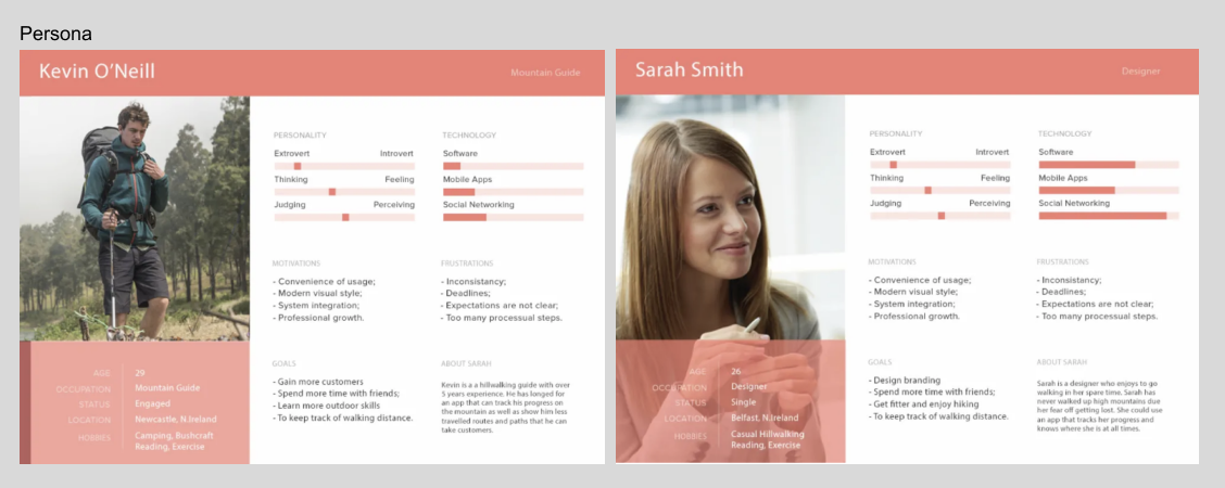
While the app and persona I've created may initially seem niche, focusing on a specific group of extreme hikers with unique needs, it demonstrates how user-centered design can evolve from an individual’s specific requirements. This persona helps define a product that directly addresses the needs of users who require advanced features for navigating challenging hikes and ensuring safety, whether or not they complete the hike within a single day.
Initially, this product targets power users—those who are more experienced and perhaps venture off the beaten path. However, this user-centric design approach can be expanded to appeal to a broader audience. For example, features like location recording and database uploads could be leveraged to create a crowdsourced map of scenic, lesser-known locations, which could later be shared with the larger hiking community. By enabling users to upload and explore routes and places that are typically outside the scope of casual hikes, we can create an inclusive experience that engages both avid adventurers and everyday explorers. This shift toward user-driven content could be a valuable addition to the app, offering broader appeal while still addressing the original persona’s needs.
This idea of gathering user-generated data and integrating it into the app is reminiscent of concepts used by companies like Niantic, which leverage location-based features and community engagement in a way that transforms a niche experience into something accessible to a much wider audience. As my persona’s needs guide the app’s design, it's important to stay adaptable and open to new functionalities that may emerge as the app grows. By listening to feedback and observing how users engage with the app, future iterations can add features that continue to support both the extreme hiker and casual users alike, ensuring the app remains relevant and valuable to a larger user base.
Overcoming GPS Limitations in Hiking Trail App Development
A key challenge in developing this hiking trail app is ensuring the reliability and accuracy of the GPS system, particularly in areas with limited or no cell phone signal. Currently, GPS technology in remote areas may not always be as robust as needed to support the ideal functionality of the app. The ability to provide real-time navigation and location tracking is crucial for user safety and experience, and achieving this in areas with poor signal strength remains a major consideration.
One potential solution to mitigate this limitation is to allow users to download maps and trail data ahead of time. This offline mode would enable the app to function using the built-in GPS on the phone, even without an active cell signal. However, this approach introduces another challenge: ensuring that the downloaded maps and trail information remain current and reflective of any changes or updates in the environment, such as trail closures, weather conditions, or new routes. This would require regular updates to the app’s data, which could be cumbersome for both developers and users if not managed properly.
Despite these challenges, I believe that with advancements in GPS technology and the growing availability of offline map systems, we are getting closer to making this type of solution viable. Additionally, leveraging real-time user-generated content—such as trail updates and condition reports—could further enhance the app’s functionality, providing a dynamic and up-to-date resource for hikers. As technology continues to improve, I am confident that we will be able to implement these features successfully, delivering an accurate and reliable tool for hikers in all conditions.
Other Projects
Use below links to explore Iris' other product design projects


